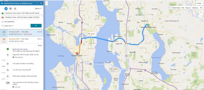
Available from today, Bing Maps can now toggle on/off for colored mapping of traffic on maps. As mentioned, this has been available as two separate features in the past. Bing Maps would previously allowed users to follow routes by seeing which areas are most congested (green least, orange middle, red most). This ability is still available, but now users can also select options that overlay color schemes for added information such as time of routes, distance, and mode of transport. Microsoft explains what each color does on a map: “While blue means no traffic delays, the orange and red colors highlight moderate to heavy traffic delays on the route. These are calculated based on a combination of current traffic updates and predictions from historic data depending on the length of the route. Traffic coloring not only helps you select the best route for your trip, but can also be very useful when there are major traffic delays due to inclement weather, big events, accidents, or road construction nearby. For example, if there is an MLB or NFL game in town, you can avoid the most impacted roads near the event and choose an option that offers the least delays.”
Continued Support
Bing Maps can also handle different terrain, allowing new visualizations to highlight difference parts of the trip depending on the landscape. Sure, Bing Maps is still a very distant second to Google Maps, but Microsoft’s support for the suite has been solid. Indeed, through a few years of consistent updates, Bing Maps is now a very solid maps package and is packed with features.